|
 Dwight Peck's personal website Dwight Peck's personal website
Summer
2005
Hiking
in the Parc National de la Vanoise
You
may not find this terribly rewarding unless you're included here, so this is a
good time for casual and random browsers to turn back before they get too caught
up in the sweep and majesty of the proceedings and can't let go. A
few days free, and hikes to be hiked. Where shall we go?
We
turn at once to our Ira Spring and Harvey Edwards, 100
Hikes in the Alps (Mountaineers Press, 1979), flip to pages 38-39,
look up with a grin and head for France. The circuit of the Aiguille de la Vanoise
(hike number 13), in the Vanoise National Park (France's first national park,
which set the standard for all those to come), is a classic walk amongst stunning
scenery in the mountainous Savoie region of France south of Lake Geneva.

We've
billeted in nearby Champagny, but we start our hike
from Pralognan-la-Vanoise, a ski resort at 1400 meters in the Tarentaise region
of the Savoy. Well, not exactly "start" there -- we "leave the
car" there, then leap aboard the télécabine up to Mont Bochor
and start from about 1980 meters instead. That's evolved thinking.

And
now we're off, 19 August 2005, heading east under the cliffs towards the heart
of the Vanoise.

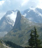
That's
the lost-looking Aiguille de la Vanoise in the centre -- our hike makes a loop
around that, over the Col de la Vanoise on the back side of it. The refuge of
Barmettes lies ahead at 2010m.

That's
the refuge of Barmettes, at the top of some of the skilift installations above
Pralognan and its suburb of Les Fontanettes.

This
is part of the ancient salt road over the mountains from Italy, leading up towards
the Col de la Vanoise.


At 2200m,
Kristin, wearing her "hiking sandals" which let the feet breathe, heads
for the Lake of the Cows.

The
Lac des Vaches (2318m), with a causeway thoughtfully provided for our convenience,
lest we get our hiking sandals wet.

So
we dart across, glance back behind us, and begin thinking about lunch.

That's
the Lac des Vaches below, from about 2450m, not looking very much like a real
lake from this angle, towards the end of a dry summer.

And
here's the Lac Long, also fairly dried out.

Views

And here
we are at the Col (or pass) de la Vanoise, and the Refuge Félix Faure at
2531 meters, casting our glances earnestly about for edelweiss and marmots.

And there's
our first marmot -- this is marmot wonderland (if you like the pesky rodent rascals),
they're strolling all over the playing field and don't seem bothered by humans
in the least. Of course, this is inside the National Park, so none of
our fellow hikers are bearing arms. Kristin, as a dedicated marmot fan, could
hardly be got to leave at the end of the day.
(True
marmot fans may want to go to the Marmot
Paradise at the top of the Rochers de Naye, the mountain overlooking Montreux,
where they can spend the day watching the little fellers scamper all round in
their cagey habitat things.)

The
newly-added part of the refuge, where the fun is.

Hikers
taking a break. Many of them are passing the night here and continuing along the
Grand Randonée (GR55) trail into or out of the Val d'Isère and Gran
Paradiso National Park in Italy on the morrow.

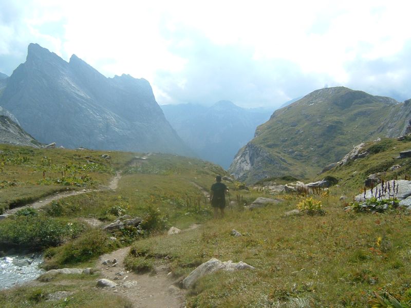
Here's
the back side of the Aiguille de la Vanoise from the col. The top of that slag
heap is said to be at 2800m, but we don't plan to plant the flag there.

This
is looking northeast up into the fog-shrouded glaciers to the east. There's someone
in the lower right searching about for the ladies' room.

That's
Lac Rond looking southeast into the heart of the Vanoise.

There's
the refuge and the Aiguille de la Vanoise again. We've been wandering about counting
marmots, out to roughly 14,263 now, but it's time to start back down and complete
the loop around the Aiguille. (We don't want to keep the chef in Champagny waiting
far into the evening.)

This
is a very companionable place, marmots and all, and it's hard to leave it. At the rate
these glaciers off La Grande Casse (3855m) are retreating (2-3 meters in thickness
per year at present), we may not get to see them again.

With the greatest of regrets, we must depart.

Kristin
pauses to encourage the stragglers before dashing down to the flat on
the right -- the "Lac des Assiettes" (2469m), now bereft of water but
perfectly swarming with little marmots.
The
smudge in the middle of the pictures is a digitalized raindrop from the previous
day.

Well,
I ask you, isn't that cuddly and feral or what?
(Soft
mangey fur, darling little incisors, sociopathic glare, your heart goes out to
them.)

There
is a science and an art to the real appreciation of nasty little marmots, and
Kristin will explain both before we leave their haunts. Sophisticated
baseball cap collecters will recognize Kristin's "Richardson Septic"
hat and urge her not to sell it but to keep it in a safe place as its market value
continues to grow.

This
beautiful gentle meadow looks idyllic, but seems to drop off a bit at the far
end.

The
path follows the creek of Arcelin down off the glaciers of Vanoise.

Mister
Spring and Mister Edwards were certainly correct to include this hike in their
100 Best. The path down through the hanging valley
of Arcelin follows a rocky spine right into the middle of the combe. Our starting
place, a couple of ridges over on Mont Bochor, has got a little red dot on it.


Above
on the left the Aiguilles of Arcelin loom nearly overhead, with the enormous glacier
of La Vanoise behind them.
Right
round here were the ruins of the Chalet Supérieur and the Chalet Inférieur
de l'Arcelin, testimonials to a bygone age before globalization.

The
Ruisseau de l'Arcelin is not particularly impressive at this point, but it gets
better (see the last picture on this page).

Here's
a look back up the way we've just been down, with a couple of German hikers tagging
along behind us.

That's
the weird, bent Grande Aiguille de l'Arcelin above us (probably. It might be the
weird, bent Petite Aiguille de l'Arcelin.).

From
this point we are counseled to follow the "ruisseau" down, until the
waterfalls anyway. Easier said than done, in a few places.

A
few more subsidiary waterfalls, joining us from the walls on the side.

Kristin
dashing across the chilly creek (glad to be wearing sandals and not boots).

A quick
glance back up the creekside path, but no time to linger, as dinner is beckoning
from Champagny.

Still
following the ruisseau, with our destination more or less visible on the valley
floor at the top left.

Now
we're heading in a light drizzly sort of rain down towards Les Fontanettes, a
trailhead above Pralognan.

This
is an interesting little gorge just coming down into Pralognan.

Which
ends here, just above Pralognan, where the local guides short-rope brave and crazy
tourists up the "via ferrata" (to the left of the waterfall) and across
the "squirrel walk", a rope walkway across the gorge not really visible
in this photo.
Time
for dinner. We've already got reservations.
The
hiking map you need is IGN Carte de Randonnée 3534 OT, "Les Trois
Vallées".

 Feedback
and suggestions are welcome if positive, resented if negative, Feedback
and suggestions are welcome if positive, resented if negative,
 .
All rights reserved, all wrongs avenged. Posted 4 September 2005, revised 21 March
2008, 15 May 2013. .
All rights reserved, all wrongs avenged. Posted 4 September 2005, revised 21 March
2008, 15 May 2013.
|