You may not find this terribly rewarding unless you're included here, so this is a good time for casual and random browsers to turn back before they get too caught up in the sweep and majesty of the proceedings and can't let go.
The Glacière de St-George and the Crêt de la Neuve

Our meeting place today, 4 November 2018, is the venerable hotel-restaurant on the Col du Marchairuz, overlooking Lake Geneva from 1445m on the road over to the Vallée du Joux. It was first built in 1844/45 and renovated some years ago with assistance from the Friends of [Amis du] Marchairuz, of which we were a member at that time.

Brilliant wood sculptures by Paul Monney of St-George

The rest of our party is a bit late, but worth waiting for. Within reason.

The party is now complete and setting off from the Marchairuz road at the northeastern end (1357m) of the pastures of the Pré de Rolle, across the road from the farm of the Pré d'Aubonne.

Our guide today will be Dr Joe, who has been perambulating all through this region for many years.

It's chilly today, but fairly sunny -- much better off than the people under the mer de brouillard, or sea of fog, covering the Lake Geneva villages below.

Along a farm road flanking the pastures at the foot of the tree-covered slopes leading up the Bois du Marchairuz

Our normal walking path passes by that three-sided shed below on our way to the Petit Pré de Rolle, 3½ km SW from the car, but today, on a whim, we're detouring a bit to visit the Glacière de St-George again, since it's been a while.

Our farm track joins a small, paved forestry road at 1300m which . . .

. . . leads down to the village of St-George (936m) far below.

Another of Paul Monney's brilliant creations, this one carved in situ from a tree stump
.
At least we reach the path up into the forest (1249m).

Suitable warnings for the unwary

Here we are. There is a ramshackle stairway leading down to a ramshackle ladder, then to another ladder which leads down to the floor of the cavern, a bit unnerving when we first scrambled down it 23 years ago, and it looks like the same old wet wood -- we'll have to think about this a bit.

We hate wet dead leaves.

La Glacière de St-George

Here's the Glacière at its seasonal best, December 2004 |
But back in the present . . .

. . . we're still thinking about it.

Errmmm

The authorities seem to have taken a strong stand on the issue: 'Glacière Fermée'.

So be it. We continue up the track through the forest.

Wait up!

This is our lovely little path through the woods -- not so little anymore, and not so lovely. The forestry people have recently been through here with their gigantic machines destroying all before them, except for some potentially useful firewood scraps.

Ooof.

It's hard to know what the Forest Stewardship Council would make of this mess of destruction, but the Hikers' Association, if there is one, would be sick at heart.

No fun at all, but the sooner we're through it all, the better.

One might have thought that a marked Swiss hiking trail would have been off-limits to the forest raiders, but maybe they're good friends with a congressman.

Machines that can go anywhere they please, and mow down all before them

Out of the forest to the pastures of the Petit Pré de Rolle (1381m)

Our guide pauses not at all. We're bound for the Crêt de la Neuve.

Eventually out of the forest -- the front slope is in view.

The assault on the front slope

A little traverse
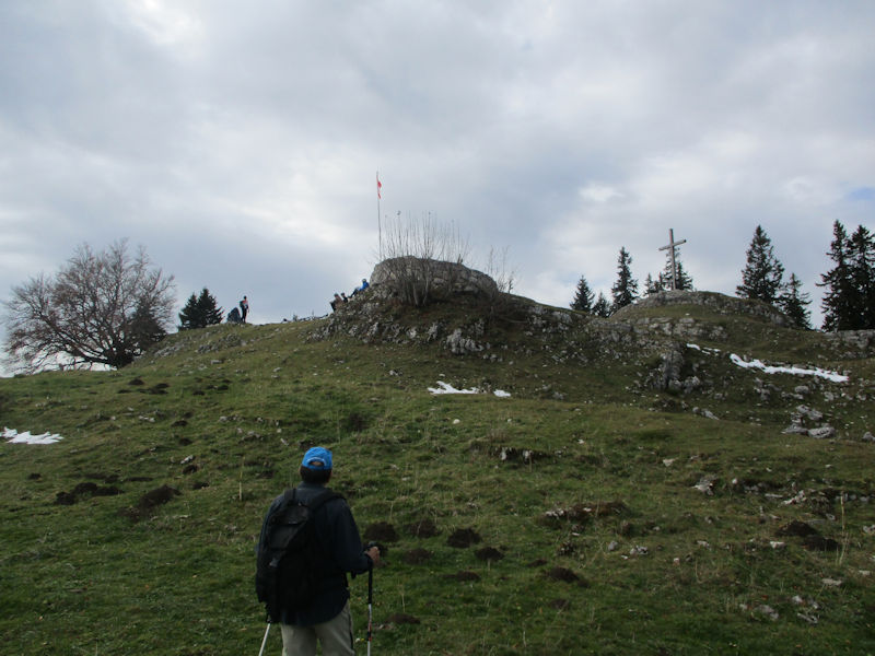
The Crêt de la Neuve is in sight. And we're not alone.

The grand old cross on top (1494m), and a cross old gentleman

The observation deck from the summit cross, on a day fast becoming overcast

Cyclists, by the look of things (i.e., the mountain bikes). And the mer de brouillard down by the lake.

And the Grand Ole Drapeau!

Picnickers nearby, and the long pasture running out to the southwest past the Perroude de Marchissy and the Perroude du Vaud. We're on the long distance hiking trail called the Chemin des Crêtes du Jura which continues along in that direction.

Lunch is over -- to the Bikes!

Such fun

We're leaving by a much less traveled way, westward down the nasty ground.

Our guide's natural enthusiasm sometimes overwhelms him.

Lots and lots of mossy limestone

Pre-dawn dining by the wild boars. It was in this place some years ago that a wild boar streaked across our path directly in front of us. It ran so fast that we're not even sure that it was a wild boar.

Forest management

A monster wood anthill just up the slope a ways

As it turns out, we're lost now. We're looking for the old, or former, section of the Chemin des Crêtes, an unmarked old path that ran along closer to the top of the ridge than the present signposted Chemin -- we found it utterly and senselessly destroyed three years ago, but we're hoping it's revegetated itself enough to make it worth a go now.

A worthy anthill, among many. This stretch of the Jura is reputed to have the highest density of wood ant anthills in Europe.

We're on the old Chemin des Crêtes now, revegetated but still massively rutted in many long stretches and frequently leading us into dead ends.

A much nicer portion of the old Chemin, for a while. We're searching for another unmarked trail, one of three that leads up to the right and passes over the ridge and down towards the Pré de Rolle.

Somewhat despairing, and not even sure anymore whether we're on the proper path or wandering off where our foresters might have sent us, one's eye providentially catches this. Probably fifty times past this point, and we've never noticed the marker before this. It seems to say 'Font Valier', for the Fontaine Valier over the ridge and down to about 1415m asl, said to be the only spring of running water over the entire length of the porous limestone ridge of this part of the Jura mountains.

Dr Joe rounds a huge anthill and heads up onto the ridge.

And down the other side, on what is here a marked hiking path

That's Fontaine Valier -- over many years passing by here, winter and summer, we can't remember ever having seen it running with water.

But it is, after all, a landmark, a 'destination', so we'll have our photo taken for the scrapbook.

Parting company at our trailhead, we're headed down the mountain to the highway along La Côte, the Lake Geneva shore, towards home at the far end of the end. Another good day.

 Dwight Peck's personal website