|
Mont Pelé's companion peak, April 2007 Winter 2006-2007 spent waiting around for winter Having found this little rocky way up to the 1515m knob between Monts Sâla and Pelé in inclement weather on New Year's Day, we've come back in April with friends. You may not find this terribly rewarding unless you're included here, so this is a good time for casual and random browsers to turn back before they get too caught up in the sweep and majesty of the proceedings and can't let go.
A pleasant approach
The walk through the forest steepens a little bit.
Kristin makes encouraging remarks and leads us upward.
Teny and Joe ponder the way upward.
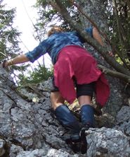
Have I introduced you to my friend Kristin?
A high order of route finding, whilst contemplating bananas, and chocolate
Limestone karst ground with holes in it at the top of the cliffs; hikers watching every step.
Kristin pauses as the stragglers catch up with the lunchbag (a couple of bananas, a little chocolate).
-- Almost there.
Kristin and Teny advancing towards lunch
Joe advancing even more vigorously towards lunch (bananas and chocolate!)
Shirts on -- break out the bananas. Followed by some chocolate.
Ah, that was nice. Now for the Cemetery of the Burgundians! (That's Mont Sâla in the background.)
Down into the Cemetery
Joe picking his way through the limestone holes looking for a way out of the Cimetière-aux-Bourguignons
And we pass Le Couchant farm towards dusk in a headlong bolt for home.
-- Where's the car?
The unmarked track begins near the stone wall, as shown by the arrow
|
 Dwight Peck's personal website


Recent Events
|