You may not find this terribly rewarding unless you're included here, so this is a good time for
casual and random browsers to turn back before they get too caught up in the sweep and majesty of the proceedings and can't let go.
A few midwinter local explorations, and the cats
McDowell, VA, and US Civil War things

We're on a little exploratory drive out west from Staunton, on US 250 through miniscule Churchville and up into the Appalachian Mountains towards West Virginia. This is a hiking trailhead off US 250 leading into the Ramseys Draft Wilderness, about 20mi from Staunton. 11 January 2020.

It's raining today, and anyway we're not in the mood, but perhaps we'll come back another day.

A 'draft' is evidently a common local word for a creek or stream (Stuarts Draft is a small town adjacent to Staunton, but the local workmen I asked about the word had no idea what it meant). We're actually on the eastern side of Shenandoah Mountain its own self at the moment.

United States Route 250 is also variously referred to on Google Maps as the Shenandoah Mountain Road, the Highland Turnpike, and the Hanky Mountain Highway.

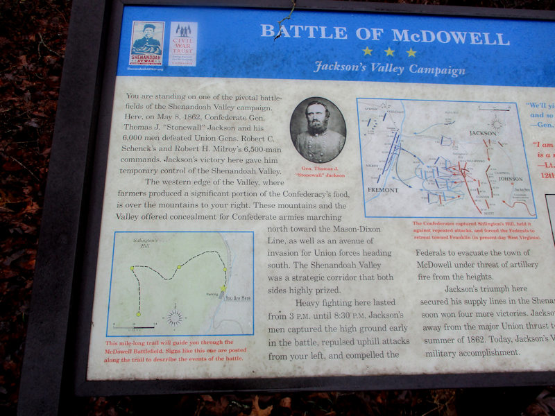
A little farther on, at a high point in the pass, or 'gap' as they say here, we're stopped at 'Fort Edward Johnson', a line of fortifications along the ridge top constructed by Gen. 'Allegheny' Johnson in April 1862 to deter two small Federal armies operating in the mountains from trying to get over into the vital Shenandoah Valley. On 8 May Johnson and Stonewall Jackson's Confederate troops hammered the Yankees down the road at McDowell in the first engagement of Jackson's legendary 'Valley Campaign'.

In the footsteps of Major Frank B. Jones, who subsequently 'succumbed to typhoid'. The interpretive maps and signs throughout these Civil War historical spots are very well done, especially for those who find the US Civil War interesting.

Over the 'gap' and down the hill
We're passing rainily through Head Waters, Virginia (also called Headwaters), located near the headwaters of the 'South Fork South Branch Potomac River'. The 'town' has a post office, in a grocery store, but scarcely enough residents to be worth counting (density 2 people per square mile).

Four miles farther on, this is the site of the battlefield, in the nasty woods above us on the mountain -- that might be worth a little walk as well someday, once it's all dried out.
(Better them than me.)

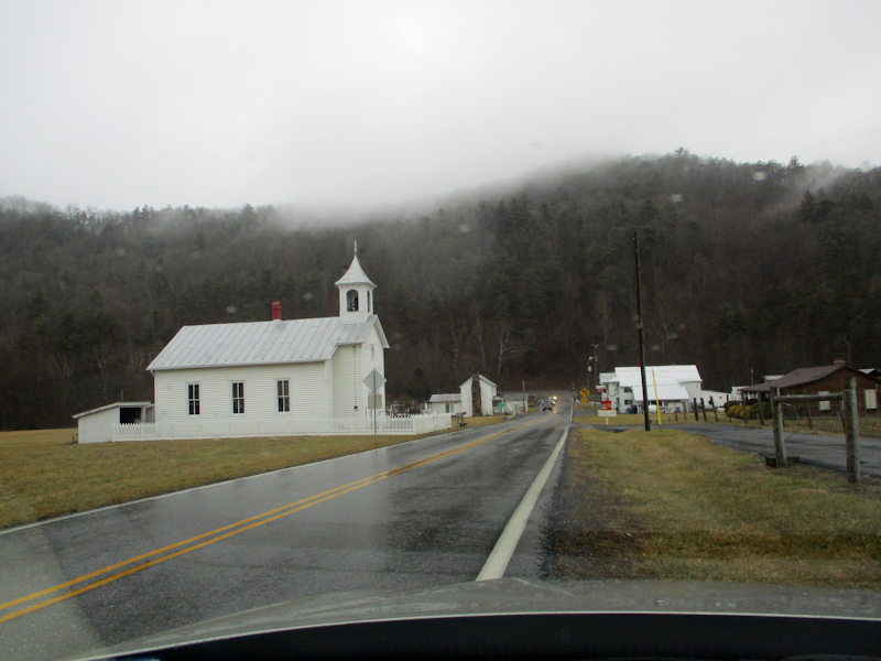
And a little farther on, here we are in bustling downtown McDowell (named for a governor of Virginia in the 1840s), located in the Bullpasture Valley near the mouth of Crab Run on the Bullpasture River.

The Highland County Sheriff's Department is on the job, or taking a pause for lunch. We passed from Augusta to Highland County at Fort Edward Johnson.

McDowell and its environs, with their other attractions, offer some potentially interesting real estate investment possibilities.

Back through Head Waters (or Headwaters), where there is no gas at the pumps today.

Onward and eastward, past Salthouse Hollow and Stamping Ground Hollow, overlooked by Mad Lick Ridge, we're approaching West Augusta on the Barn Lick Branch of the Calfpasture River -- another town where evidently no one wants to commit to population estimates.

Hurtling along the Hanky Mountain Highway, soon to be passing the Stonewall Rifle and Pistol Club on the Spruce Lick Branch.

The Buckhorn Inn and B&B can boast that it is a 'secluded pick', built in 1811, and 'less than a mile from the Stonewall Rifle & Pistol Club'. It does look rather nice.
Cats

Home again, where the cats are cooperatively perched on their favorite chair

Their next best favorite perch is next to or on the keyboard.

The third best perch, on top of the Cat Tower

Kristin's out of town for a few weeks, so the post is stacking up, literally.

Another favorite perch
The Mary Gray Wilderness Expedition

The imposing peak in front of us is Staunton's Betsy Bell Wilderness Park, which however is old hat for us by now, so today we're on our way to explore Betsy Bell's 'sister summit', the Mary Gray Wilderness Park behind us, 27 January 2020.

'Well begun is half done', but as we subsequently learnt, we're already way off the recommended path.

A landmark, which we'll keep in mind for finding our way back again later

Another landmark, worth remembering

We've lost the trail but haven't given up hope yet.

Quelle surprise! Dejà!

We haven't been especially hurrying, but this has to be our fastest 'wilderness summit' yet. A bit less than ten minutes.

A pleasant path round the summit and back down

An embarrassment of choices. What now?

Certainly very pretty, if not actually too much of a 'wilderness'

Especially since there, below us, lies what very well may be a Walmart Superstore

Our landmark -- we know where we are now.

But we're not going that way. What a mess.

Here's another path -- it wouldn't hurt the Tourist Office to clean that up a bit.

Civilization! We're saved.

There's a whole 'nother world down here.

That is a Walmart Superstore after all. And a Lowe's, for household goods.

And a Martin's supermarket, adjacent to our wilderness. And in the background, someone has posted 'Jesus Loves You' on the side of a building, for some reason. (Perhaps it's a code.)

This, it transpires, is a residential development called the Big Sky. For some reason.

Back we go, up into the wilderness.

Quite an adventure.
 Dwight Peck's personal website