You
may not find this terribly rewarding unless you're included here, so this is a
good time for casual and random browsers to turn back before they get too caught
up in the sweep and majesty of the proceedings and can't let go.
Pointe
de Poêle Chaud, 2 April 2006
It's
already April, the snow is melting, and if we don't go soon we'll miss it for
this year. The Pointe de Poêle Chaud is a lovely steep little peak (1628m)
adjacent to La Dôle, hovering over Lake Geneva and the town of Nyon.

We've
made a fair start from the La Cûre-St Cergue road over the Col de la Givrine
-- the sunny Sunday crowds are gone now, so parking's not a problem. We've just
reminded Dr Pirri to go back and get his backpack off the roof of the car, and
now we're ready to make a fair start once again, with the lunch coming along with
us this time. This fine specimen of carhood, named "Dieter", is now
at 1205m altitude, and so are we, but not for long.

We're
passing the farm-cum-ski restaurant of La Trélasse, not far from the carpark,
bound up that slope on the left.

La Trélasse

We begin our day with a brisk plod along a road for a ways

And soon we're ready to start up the hill.

Dr
Pirri gains a few points for being first to the Col de Porte (1559m), though it's
only now, as he's shouting down the hill at us, that we've learnt that this was
a race. The points are under consideration by the Appeals Committee.

The Col
de Porte lies between the Pointe de Poêle Chaud and La Dôle, each
a hundred meters higher, and that's the poignant memorial cross on the side of
the way up towards La Dôle.

Dr
Pirri, enjoying the extraordinary scenery, struggles to figure out how to use
his camera.

The
ski-club hut and water company station adjacent to the Col de Porte, on a hillside
facing due south.

Dr
Pirri pointing tentatively towards Pointe de Poêle Chaud. Nonchalant, as
if it didn't matter. The clouds are darkening again.

The
Chalet de la Dôle, in a bowl at the foot of the cliffs at 1439m. Lake Geneva
in the background.

Not a
great photo to place here,
but for curiosity's sake, that's Geneva's famous "jet
d'eau" (water jet) making a little whitish 140m-high blur at the end
of the lake, in the center of the frame. They've got diplomats down there, United
Nations stuff like WHO, ILO, WMO, UNEP, CITES, WIPO, you name it, bigtime industrialists
and bankers, a rich heritage of theological insanity under Calvin, and the Pâquis
with its American-style motorcycle shops, streetcorner hookers not all of whom
are gender-specific, and the American Church. But we can't actually hear a word
of that up here.

The
top of the skilift on the right and a thrillseeker's ski track above the cliffs
on La Dôle.
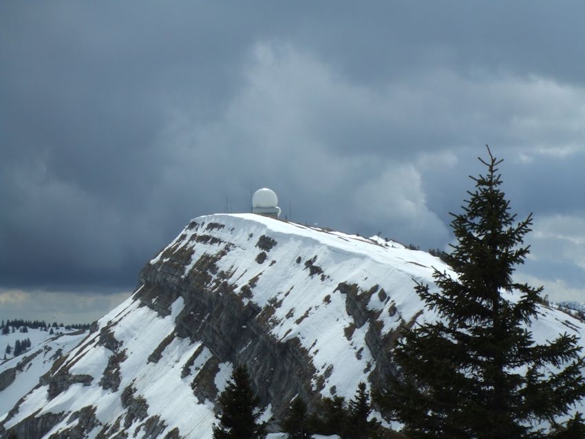
The
radar station at the top of La Dôle. This is the photo angle that, like
the Castle of Chillon, cannot go wrong.

Dr
Pirri approaching the amateur radio relay station on the top of Pointe de Poêle
Chaud, contemplating lunch.

Dark
clouds are in and out today, and the temperature is bouncing up and down like
a yoyo as the sun peeks through and sees enough of humankind to change its mind
and duck back out again.

A
misleading photo of the radio station on top of Poêle Chaud -- the propeller
on the wind gauge tower looks stationary, but was in fact whirling crazily around
with an irritating whine.

We're
pausing in our hike for a few moments to photograph the scenery whilst Dr Pirri
continues digging about looking for his lunch.

Unpredictable
clouds. Back in Oklahoma, when we saw dark clouds massing like this, we
put the children in the bathtub and laid a door over it, to protect them from
the flying glass, and went back to the party. Up here, we just hurry our lunch
and try to get off the summit ridge before the sleet hits the fan.

It's
almost time to return to earth, alas, as the day wanes, and that looks like the
last bit of blue sky we're going to see for a while. It is hard even to imagine anything more beautiful than a scene like this one.

The
narrator, poised to remind Dr Pirri to remove his finger from the lens. Luckily,
he had already begun to do that on his own.

A last look at La Dôle, as we going down off the farther side of Pointe de Poêle Chaud

The track
down to the northeast to make a roundtrip over Poêle Chaud's summit ridge.
Most snowshoe tracks go in single file, as hikers seek to benefit from the work
of their predecessors, but when snowshoe tracks go alongside one another like
this, you can assume that the hikers were entertaining each other with
their George Bush impersonations. The tip of the radio station can just be seen
on the ridge.

Down along the ridge

Dr Pirri
hastening to beat the sleety sort of precipitation, the Pointe de Fin Château
at the end of the ridge. We're proposing to descend into the forest on the left
just before that.

Poking out of the steep hillside, providentially right at the Trélasse farm

As the
sun re-emerges at about five p.m., we conclude our re-visit to the Pointe de Poêle
Chaud, 2 April 2006, go back to the car, and amuse ourselves by trying out our
"Dick" Cheney impersonations all the way home. "Grrrr-- Snarl,
grrrr."

From
the Carte National de la Suisse, 25,000 scale: 1261, Nyon (1992)
The
orange dot marks the farm of La Trélasse. The green dot marks the railway station
at the Col de la Givrine. The brown dot indicates the farm of La Givrine. Blue
shows the top of Pointe de Poêle Chaud.

From
the Carte National de la Suisse, 50,000 scale: 260, St.-Cergue.
The frontier of France to the south and west is marked by +++++++.

The
little red train passing over the Col de la Givrine near La Trélasse, 2
April 2006.
 Dwight Peck's personal website