|
 Dwight
Peck's personal Web site Dwight
Peck's personal Web site
Winter
2005-2006
Short
breaks from poring over the newspapers as the Bushies implode
Devon
and Cornwall in the springtime
Whenever
things start to pile up and get on top of you, it's time to take some time off
and go to Cornwall.
You
may not find this terribly rewarding unless you're included here, so this is a
good time for casual and random browsers to turn back before they get too caught
up in the sweep and majesty of the proceedings and can't let go.
Sennen
Cove and Land's End on the Southwest Coast Path, 20 April 2006

Kristin
and some of the old mine works on the coast near Botallack. We're setting off
on a rain-threatening day from Botallack Manor to Land's End.

The
Crown Mine engine houses at Botallack, closed down in 1895, restored in 1985
"There
are two engine houses at the Crowns. The lower house held a 30-inch pumping engine,
built in 1835 to replace a smaller engine at the same location. It was built on
the bare rock with no foundations, the rocks being bolted and mortared in place.This
building weighs around 1200 tons, all brought down the cliff. In addition the
metal work weight about 100 tons. Above this is the winder for the Boscawen Diagonal
Shaft, built in about 1860." (reference) |
Some
of the tin mine shafts are said to extend out under the sea for as much as a kilometre
-- the novelist Wilkie Collins ventured into one of them in its heyday and claimed
that he could hear the surf overhead (Rambles Beyond Railways, 1851). The
upper engine house powered wagons running up and down the rails in a 32-degree
inclined mine shaft. Naturally, there were appalling disasters from time to time.
Thus the modern Cornish strength of spirit.

The ruins
of the mines are ubiquitous throughout the region and especially along the Coast
Path. Whoever started it off -- Celts, Phoenicians, Raelians -- millennia ago,
the remnants of the industry are the hallmark of the region, and the loss of the
industry is its curse. (Especially after the wool industry did a runner as well.)
But if the old shafts and engine house don't produce tin now, they do produce
historically-minded tourists, and that's going to have to do.
You
may wonder why Cornwall had the mineral mines that the rest of Britain missed
out on. There is a simple geological explanation. During the late stages of the
cooling of the mass of granite that makes up a lot of Cornwall, fissures opened
up in the granite when it was still molten, and more hot molten rocks bubbled
up through the granite from the earth's interior. These new rocks contained many
minerals, and as they crystallized they formed mineral lodes - tin, copper, zinc,
lead and iron with some silver. Because the ore bearing rocks formed in this way,
rather than being sedimentary rocks like coal (hence coal is laid down in great
flat plates), they have to be mined vertically rather than horizontally. Each
fissure has to be mined straight down into the earth. Each fissure needed a separate
mine. Therefore a great many vertical shafts were needed, rather than the one
shaft that was used in coal mining.
Inevitably
the mine shafts dropped below the level of the water table, and the water had
to be pumped out if mining was to continue any deeper. Hence pumps and the houses
for the engines that drove the pumps were a necessary part of mining. These engine
houses were the sturdiest buildings in the mines, as they had both to house the
machinery and support the massive beams that worked the pumps. It is not surprising
that it is the engine houses that survive in Cornwall. In addition the closer
to sea level the engine was sited, the less the height the water needed to be
pumped to remove it from the mine. Therefore we find today some of these engine
house perched on the sea cliffs.
Cornish
Mines and Mining History in Cornwall |

This
is famous Cape Cornwall, supposedly "England's
only cape", which is supposedly a projection of land that separates two seas
(like Cape of Good Hope, Cape Horn). Well, okay, but if you can see a difference
between the sea on the left (the Atlantic Ocean) and the sea on the right (the
Atlantic Ocean), inform someone at once. Some Victorian
Horatio-Alger figure made his fortune exploiting the natives in South Africa and
came back, calling himself "the Colonel" no doubt, to establish himself
here, build the monument out there, and call this "the Cape".
Wikipedia
to the rescue
Cape
Cornwall is a small headland in Cornwall, England, four miles north of Land's
End near the village St Just. The cape is the point at which Atlantic currents
split, either going south up the English Channel, or north into the Bristol Channel
and Irish Sea.
The
cape was once thought to be the most southwesterly point in mainland England;
however, following accurate surveying, Land's End was found to be the most westerly
point. |
The
site is also notable because a bunch of Romans left behind some extremely early
Christian symbols here, and the vicar missed the point and threw them down the
well, so they've gone back to heaven now. The photo above was taken from the Coast
Path, where sadly it skirts along the edge of a 900-hole Country
Club golf course.

Mine
shafts are everywhere. Luckily, they all come outfitted with that little yellow
square "danger sign" to alert you before it's too late.

The Southwest
Coast Path provides some of the most delightful walking you'll find anywhere.
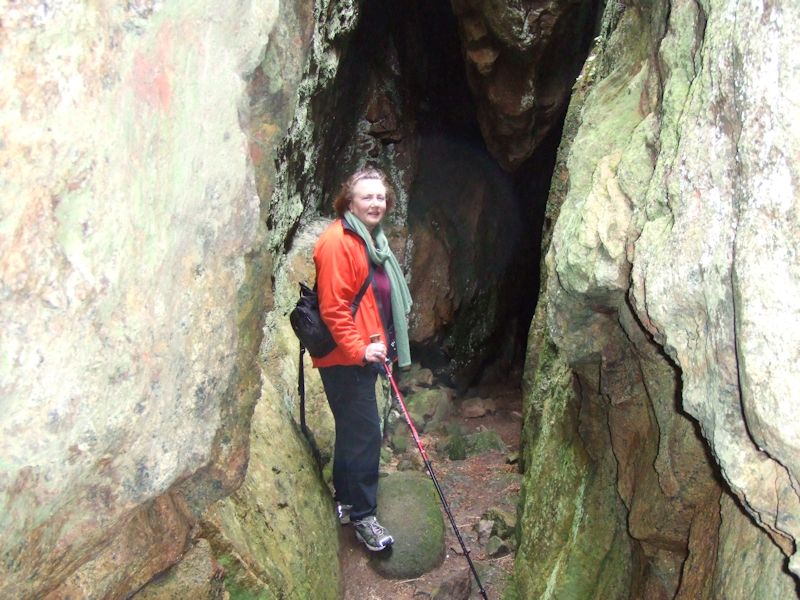
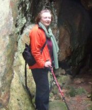
With
surprises. This fissure leads who knows how far back into the cliffside. It being
nearly summer and all, we dumped out the hiking headlamps before leaving home,
so we couldn't get more than 40 meters into it, even by blasting off the camera
flash.

The
narrator, where once tin, copper, zinc, and arsenic snuggled side-by-side cozily
for eons.

A
bit of the beach of Sennen Cove appears in the distance, as the rain begins to
take itself seriously.

Sennen
Cove, on the way to Land's End

The caption
should have read "It's amazing what you can do to an Atlantic grey seal with
just a ski pole", but that didn't seem right this time. That poor guy was tied up around the tail and killed some time ago, some unpleasant
story there! (Not the one in orange, that's Kristin.) Not something you'd normally
want to just leave lying around on your beach (the seal, not Kristin).

Kristin
abandons the Coast Path (up over the cliffs) to look for little nature things
in the intertidal pools.
Here
comes the rain!

Just
(in a conventional adolescent manner) to complete the "mission", one dashes along
in the rain the last mile from Sennen Cove to Land's End. Here
it is (don't worry about WHAT that is, we'll be back later in better weather).

Now,
this looks like a REAL cape! The First and Last House (sic) and "The
Longships" out in the fog, with the lighthouse on it.

Views
in the rain near Land's End (the Earth giving the finger to the Sky, or to Somebody
Up There?)

Rainsoaked and windbattered, longing for a look at The Guardian, one returns to
Sennen Cove (the lower part, along the beach) from the Land's End side.

Back
in Sennen Cove, Kristin in our absence has just scored both The Guardian and The
Independent and learnt that we've missed the last bus back to St Just.

Never
mind, we call a taxi and go have a nice cuppa (or pint-a) in the Old Success Inn
in Sennen Cove (dreaming of the Queen's Arms a few hours hence), reading The Guardian
and The Independent, respectively.

Pubcrawling
in Devon and
Cornwall, 2006 |
|
|
|
|
|
|
|

 Feedback
and suggestions are welcome if positive, resented if negative, Feedback
and suggestions are welcome if positive, resented if negative,  .
All rights reserved, all wrongs avenged. Posted 6 May 2006, revised 16 September 2008, 6 May 2013. .
All rights reserved, all wrongs avenged. Posted 6 May 2006, revised 16 September 2008, 6 May 2013.
|
