|
Favorite running routes near Leysin, Switzerland For an extremely pleasant 12 years or so, Mr Peck was privileged to be able to run back and forth all about the Swiss Alps in the region of Leysin -- a mid-life Grace Period, so to speak: a window of life's opportunity.
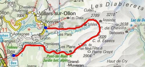
At the end of 1992, Mr Peck was constrained by impersonal economic forces to leave Leysin and, a few years later, through an accumulation of semi-vicious injuries, chose to take up bicycling instead (which is also fun), and has since been quartered nearer to Geneva anyway. ARGENTINE LOOP From Barboleusaz near Villars (1211m) 5.5km up road to Solalex (1462m), 2.5km up path to Anzeindaz (1876m) and 1.5km to Col des Essets (2029m); down paths 7.25km to Pont de Nant (1253m), path 2.1km to Plans-sur-Bex, 9.25km down road to Bex gare. 28.15km, 840m elevation gain. [Some photos of the area]
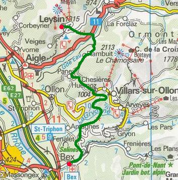
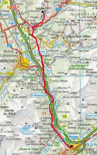
BEX from LEYSIN From Leysin American School through the village down to Pont de la Tine (806m) on the Grand Eau, up to rail line at Exergillod, up forest from Dard bridge to Plambuit village (1123m), up road to Les Ecovets above Panex (1285m), down through Huémoz on path through ravine to Le Fondement (855m) below Villars, out to Fenalet village and down road to Bex gare. 26.1km, 590m elevation gain.
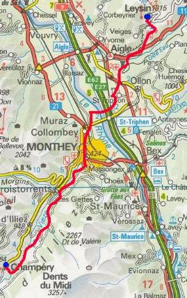
From Leysin 5.85km down to Aigle Depot, 3.7km to St. Triphon, past Collombey 6.75km to Monthey (424m); up ravine past Chenarlier, Troistorrents 7.2km to Val d'Illiez bridge; path through forest 6.9km to Champèry gare (1053m). 28.3km, 760m elevation gain.
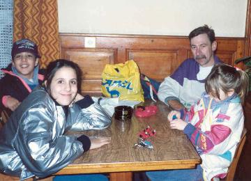
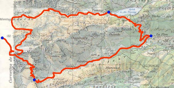
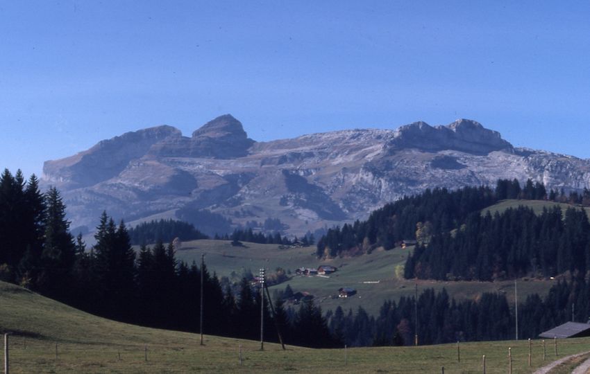
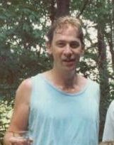
A pale and devastated gentleman is met by young friends in Champèry in December 1991 after a very icy run up the sunless ravines from Monthey. CORNETTES DE BISE LOOP From Le Flon (1049m) 5.1km past Plan de l'Ortie and Verne farm to Col de Verne (1814m); up steeply past La Calaz hut (2064m) onto rocks 1.9km to Cornettes de Bise (2432m). Down to Rochers de Chaudin, Chaux de Milieu bowl, 2.15km to Les Traverse (2080m), 2.4km round Montagne de l'Au (de Loz) to Loz farm (1830m); 3.2km to Lac de Tanay (1415m). Over Col de Tanay (1440m) 2.75km to Le Flon. 17.5km, 1408m elevation gain. [Some photos of the area][and photos of Tanay]
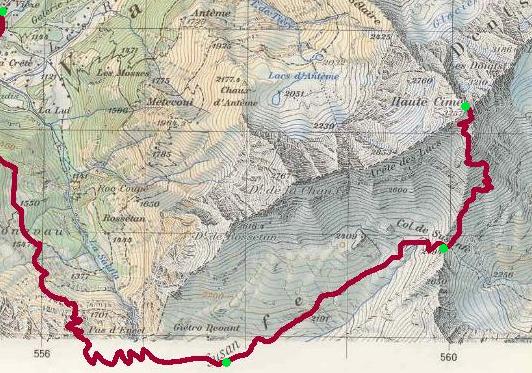
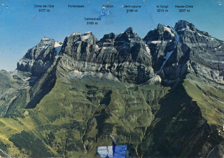
DENTS DU MIDI from Champéry and return From Grand Paradis by Champéry (1055m) up steep forest path past Bonavau farm (1550m), through Pas d'Encel to the Cabane de Susanfe (5.626km, 2101m). Up to Col de Susanfe (2.125km, 2494km), mud track through 2700m-rockband to Col des Paresseux to Haute Cime of Dents du Midi (1.875km, 3257m). Down same. Total 19.25km, 2207m elevation gain. [Some photos of the area.]
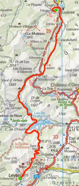
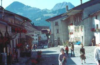
GRUYERES from LEYSIN (from Feydey) From Leysin Feydey past Les Fers 8.625km to Pierre du Moëllé; down to the Lac d'Hongrin, crossing the ravine at Jaquemin, hillside path 7.75km to the Barrage d'Hongrin; down road 7km to Allières, 5km down to Montbovon; 15.13km on far side of the valley through Lessoc and Grandvillard, riverside path on the Sarine to Epagny, to Gruyères. 43.5km, 555m elevation gain.
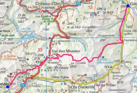
GSTAAD from LEYSIN, via MOSSES From Leysin Feydey past Les Fers and Solpraz 12.75km to Les Mosses (1445m); up Pra Cornet (1653m), 6.95km down to Maulatreys (1278m); up 2.55km to col at 1883m; past Seron & Sazième 2.75km to Fenêtre-d'Arnon (1885m); 2km down to Lac d'Arnon, 5.15km down road to Feutersoey (1130m); 6.7km on path parallel to highway to Gstaad. 38.85km, 1259m elevation gain.
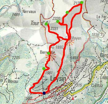
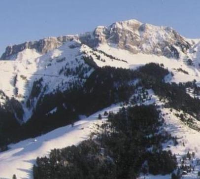
LEYSIN SIX SUMMITS (Quarry to Quarry) From the quarry at the top of the village (1470m) up the yellow trail past Lac de Mayen, over rock above the Combe de Bryon 6km to the Tour de Famelon (2137m); over Les Truex (2194m), down to Lac de Segray, 2.65km up to Tour de Mayen (2326m); past Segray and Lac de Mayen 3.95km to Tour d'Aï (2331m); past Lac d'Aï 2.38km to La Berneuse (2048m); through Col du Luisset 1.2km to La Riondaz (1980m); 2.45km past La Prafandaz to the quarry. 18.6km, 1880m elevation gain.
Four of the Leysin Six (from left: Tour d'Aï, Tour de Mayen, Sur les Truex, and Tour de Famelon).
From Leysin American School down Ponty path 5.85km to Aigle depot; through vineyards to highway 8.7km to Bex gare; 3.5km to St Maurice bridge; 9.25km over Bois Noir through Evionnaz and Miéville past Pis-Vache; 6.35km through Versayaz to Martigny gare. 34.3km, 100m elevation gain. (Alternative: from St. Maurice 9.25km along Rhône past La Balmaz to Dorenaz bridge; 5.5km through orchards of Ferme-des-Iles, to Martigny gare. 33.8km.) (A straight road run, for training rather than aesthetic purposes.)
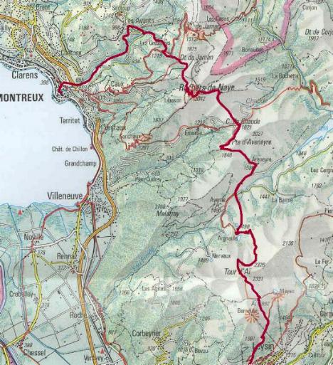
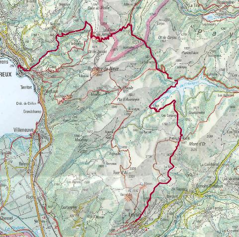
MONTREUX from LEYSIN, by ROCHERS DE NAYE From quarry above Leysin (1470m) up yellow trail to Lac d'Aï, Sphinx trail past Tour d'Aï to Chaux de Mont (4.5km, 2205m); down behind Tour d'Aï to Grand Ayerne in the Hongrin valley (4.5km, 1452m). Up Les Cases 2.9km to Pierre Pertuis near Aveneyre (1846m); down difficult path in wet weather 1.85km to Col de Chaude (1621m). Along crest of Essettes 2.85km to Rochers de Naye summit (2042m). Down steep Sautodoz gulley, past Merdasson and Paccot, 6.6km past Les Gresaleys to Pont Bridel bridge (900m) and up road to Les Avants village (968m). Down Gorge du Chauderon 4.5km into old Montreux and to rail station. 28.0km, 1780m elevation gain. Stunning scenery.
The Rochers de Naye with the gulley of Sautodoz at the far right, and the route down Paccots to Gresaley in the foreground. MONTREUX from LEYSIN, by LAC D'HONGRIN From Leysin Feydey out past Les Fers 8.625km to Pierre du Moëllé; down to Lac d'Hongrin road, southwest on road and across Hongrin ravine at Jacquemin/Les Joux, on path to L'Hongrin dam (7.75km). Down road 7km to near Allières village; up path 3.25km through Les Cases to Col du Jaman; down road 4.55km to Les Avants (968m); down Gorge du Chauderon 4.5km to Montreux gare. 35.7km, 1031m elevation gain.
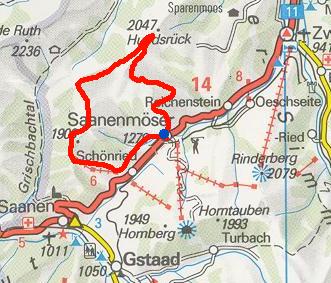
SAANENMÖSER SIX SUMMITS From Saanenmöser 3.8km to Wannehörli (1942m), .7km to Birehubel (1937m), 2.4km to Schneitgrat (1960m), 1.5km to Planihubel (1879m), 1.3km to Hugeli (1898m), 1km to Rellerli restaurant at top of skilifts (1831m); 3km down to village of Schönried, 2.6km on back roads to Saanenmöser. 16.25km, 1255m elevation gain.
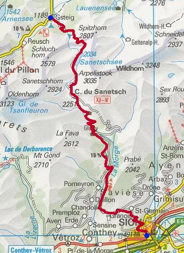
SION from GSTEIG From Gsteig village (1184m) 5.5km up path under waterfalls to dam at Lac de Senin (2035m), alongside road 3.875km to Col du Senin or Sanetsch (2243m); 2km down Tsanfleuron flats through cliffs, 8km past Pont du Diable, 3km past 770m, up to Chandolin (818m), 6km on road to Granois (857m), down through vineyards to Sion gare (500m). 27.65km, 1158m elevation gain.
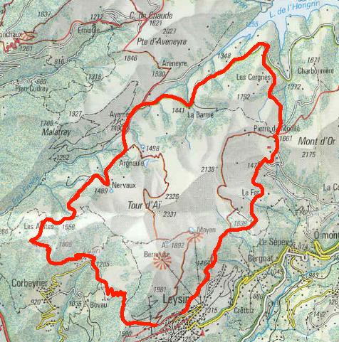
Tour of the Tours (around the Leysin mountains) I. From Leysin Feydey past Les Fers 8.625km to Pierre du Moëllé; 3km down to military road at Rossière above Lac d'Hongrin; 5.25km along road to Grand Ayerne military HQ; 5km on road to corner at Les Agittes overlooking Rhône valley; 3.7km down road through the tunnel of Sarse to Luan village; 3.5km up Praille ski slope to Prafandaz above Leysin, down to quarry. 29.61km, 848m elevation gain.
II. From the quarry above Leysin (just below Prafandaz), over Praf, 3.5km down ski slope to Luan café; 3.7km up through Sarse tunnel in cliffs to Les Agittes corner; 5km on military road to Grand Ayerne, continuing 5.25 to Rossière above Lac d'Hongrin; up rocky road 3km to Pierre du Moëllé; 8.625km past Les Fers past Leysin Feydey to Chalet Pollux. 29.65km, 848m elevation gain.
Setting out for Beinn Deargh, 1990
Morat-Fribourg marathon, 1991
|
||||||||||||||||||||||||||||||||||||||||||||||||||||||||||||||||||||||||||||||||||||||||||||||||||||||||||||||||||||||||||||||||||||||||||||||||||||||||||||||||||||||||||||||||||||||||||||||||||||||||||||||||||||||||||||||||||||||||||||||||||||||||||||||||||||||||||||||||||||||||||||||||||||||||||||||||||||||||||||||||||||||||||||||||||||||||||||||||||||||||||||||||||||||||||||||||||||||||||||||||||||||||||||||||||||||||||||||||||||||||||||||||||||||||||||||||||||||||||||||||||||||||||||||||||||||||||||||||||||||||||||||||||||||||||||||||||||||||||||||||||||||||||||||||||||||||||||||||||||||||||||||||||||||||||||||||||||||||||||||||||||||||||||||||||||||||||||||||||||||||||||
 Dwight Peck's personal website