|
 Dwight
Peck's farm photos Dwight
Peck's farm photos
Farms
of the Jura in winter
The
Jura mountains run in a southwest-northeast direction along the border between
France and Switzerland, from Geneva (Genève) to Basel (Bâle), holding at about
1300-1400 meters altitude (4350-4500 feet), and peaking in the range of 1650 meters
(5450 feet). These photos of high alpage farms in winter are mainly from the southwestern
end of that range, between the cities of Geneva and Vallorbe.

La Sèche des Amburnex

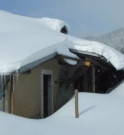
La
Sèche des Amburnex lies at 1297m in a closed combe between the main Combe
des Amburnex to the southeast and the Jura ridgeline to the northwest. 10 February
2008, the year with almost no snow.

As
dedicated Jura farm photo collectors, we're circling round the building now, looking
for just the right angles and sunlight.

So
this really is a P5, after all.

I
have no notion what "P5" on a farm building might mean,
but we'll file this one under "P5" anyway, to be safe. "P5"
presumably has some secret meaning, but it's probably Masonic and needn't concern
us here.

4
March 2007, a sunless day

The same

5 April 2009

from SwitzerlandMobility (http://map.schweizmobil.ch/?lang=en)

Sèche des Amburnex, 25 March 2012

Not long ago we were passing by and were gobsmacked to find that most of the building was gone, and we are so pleased to find that it's been put back again, and much improved.

It almost looks new, and mostly is.

New roof, that's good, a nice new wooden rain-capture system, and renovated walls, it looks like.

And a whole new end of the building


The farm zoomed from the northeast
 Feedback
and suggestions are welcome if positive, resented if negative, Feedback
and suggestions are welcome if positive, resented if negative,  .
All rights reserved, all wrongs avenged. Posted 3 April 2007, revised 28 March 2012, 5 September 2014, 23 January 2020. .
All rights reserved, all wrongs avenged. Posted 3 April 2007, revised 28 March 2012, 5 September 2014, 23 January 2020.
|